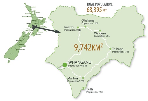
The Whanganui District Health Board served a population of 68,395* and includes residents of the Whanganui and Rangitikei Territorial Authority areas, as well as the Ruapehu Territorial Authority area wards of Waimarino and Waiouru – known as South Ruapehu.
Our region covers a total land area of 9742 square kilometres, much of which is sparsely populated. The terrain is mountainous with two major centres - Whanganui city with a population of 46,944 and Marton with a population of 5268. The major centres are supported by five smaller towns with a population less than 2000 - Waiouru 765, Taihape 1716, Bulls 1935, Ohakune 1182 and Raetihi 1038*.
The population of Whanganui is characterised by a large percentage of Māori at 27 percent of our population (compared to the New Zealand average of 15.7 percent) and small but growing populations of Pacific and Asian people at 4 and 5 percent respectively.
Compared to New Zealand’s 19.6 percent, our district is home to a higher percentage of children and young people, with 20.2 percent under 15 years of age, of which 43 percent are of Māori ethnicity. This reflects the younger Māori population of our rohe compared to the rest of the country.
Whanganui has a higher than average population of older aged citizens – with 19.7 percent older than 65 years of age (compared to 15.4 percent for the rest of the country in 2018). As older people, like young people, are high healthcare users, this demographic change has significant implications for future provision of health services.
*Data based on Ministry of Health and Census 2018 data sources


